
Utilis value proposition
Utilis Ltd.is a start-up company that has developed a cost-effective software solution for detecting leaks in urban drinking-water supply systems, utilizing a novel one-of-its-kind remote-sensing technology. Providing pinpoint accuracy of leakage locations, without any prior field exploration required, the Utilis analytic technology helps municipalities and utility companies reduce the amount of NRW (non-revenue water).
Since its inception in 2013,Utilis has conducted vast research, gaining expertise in the analysis of urban water networks by means of unique micro-parameters that provide a remarkably accurate solution. Comprising a team of experts in geophysics, hydrology and water-network management, Utilis has managed numerous projects across the globe, including in the U.S., South America, the EU and Israel, which have yielded highly successful, proven results.
Partial solutions to a growing problem
Municipal, governmental, and private utility corporations deal with the alarming statistic that 30% of drinking water is lost before it even reaches consumers - a looming problem that is due primarily to old water piping systems worldwide.
Detecting underground leakages can take several years. Yet, drilling to locate the source of a suspected leak is costly and inconvenient for residents and businesses, and may result in a “dry hole.”
Available solutions today for leak detection address only partial aspects without providing cost-effectiveness or accuracy. Some rely on field experts, while others use smart-metering and sensor-detection equipment, which are costly and time-consuming, requiring on-site inspection of each individual pipe. Another approach - hydraulic modelling - is highly inaccurate, while the big data approach is a partial, costly solution.
Unique solution and benefits
Utilis provides a comprehensive, highly accurate, non-destructive remote-sensing solution for locating the sources and volume of leaks in urban water network, regardless of leak volume or demographic density, providing full coverage of forests, mountains, buildings or highly-populated areas. By extrapolating information from aerial images taken above the ground, and converting it within minutes into precise coordinates of underground water leaks, Utilis enables utility and water-treatment companies to make educated decisions and act quickly.
The Utilis solution offers 3 main benefits:
• Cost effective, saving on unnecessary drilling and detection equipment, metering data, no “dry holes”, and lowering the price of water for residents.
• Saves vast amounts of lost water, a fast and efficient solution that processes a remarkably large area instantly, enabling quick response time.
• Highly accurate, remote, and autonomous, requiring no surveys or professional training.
Technology
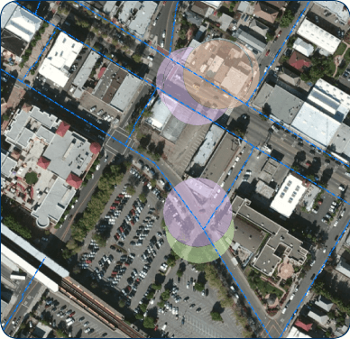
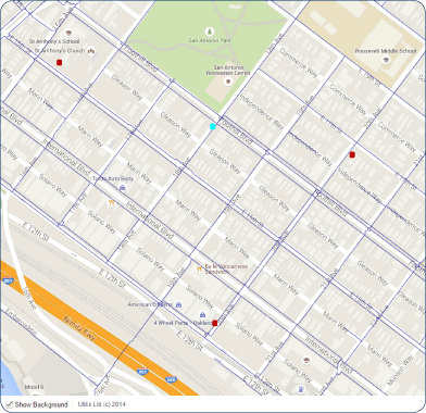
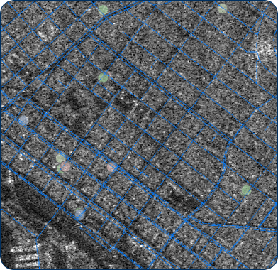
Utilis innovative technology is based on the analysis of multispectral aerial-images that capture the area of a suspected leak, enabling water utility companies to easily and accurately identify leaks, their sizes and volumes. By processing these images and applying unique algorithms, the system uses essential physical parameters, such as geological, meteorological, and hydrological factors. After calculating and adjusting for any distorting factors, the information is intersected with piping infrastructure layouts, and the system indicates locations of underground water leakages.
After comparing specific parameters in images taken in the same area at different times, the proprietary GIS system generates an analytic report with GPS coordinates on a map, showing highly-probable leaks in a remarkably precise geographic location.